Emergency Flood Notification
Recent updates get posted to our facebook page first before the get posted here. You can follow us at https://www.facebook.com/BentonFire2/.
12/13/25 11:45 (11:45AM)
We have officially hit the crest and are already seeing the water level slowly beginning to recede. At the moment, we are just shy of the 16.25’ mark. We do have actual field evidence of recession though and it will slowly continue to do such.
We will continue to monitor this closely as we have been however, our consistent updates will begin to spread out.
12/13/25 10:30 (10:30AM)
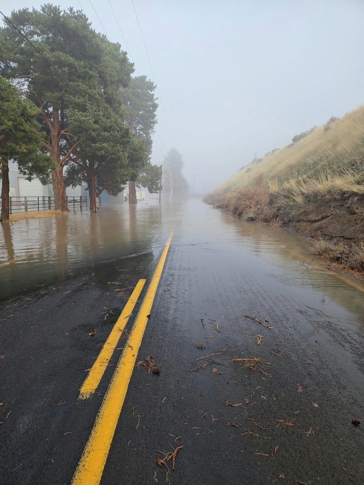
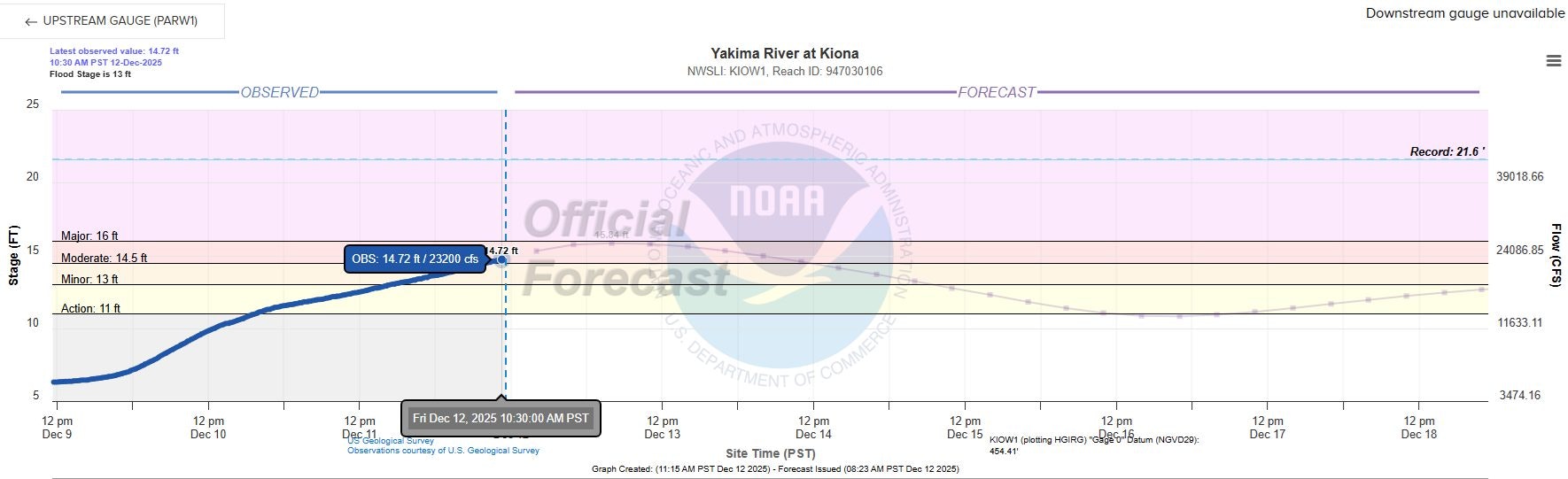
We are nearing what is anticipated to be the crest of this water event. It did go above and beyond the predicted latest 16.09’, currently at 16.14’ and has caused some water over the road way on Demoss Rd.
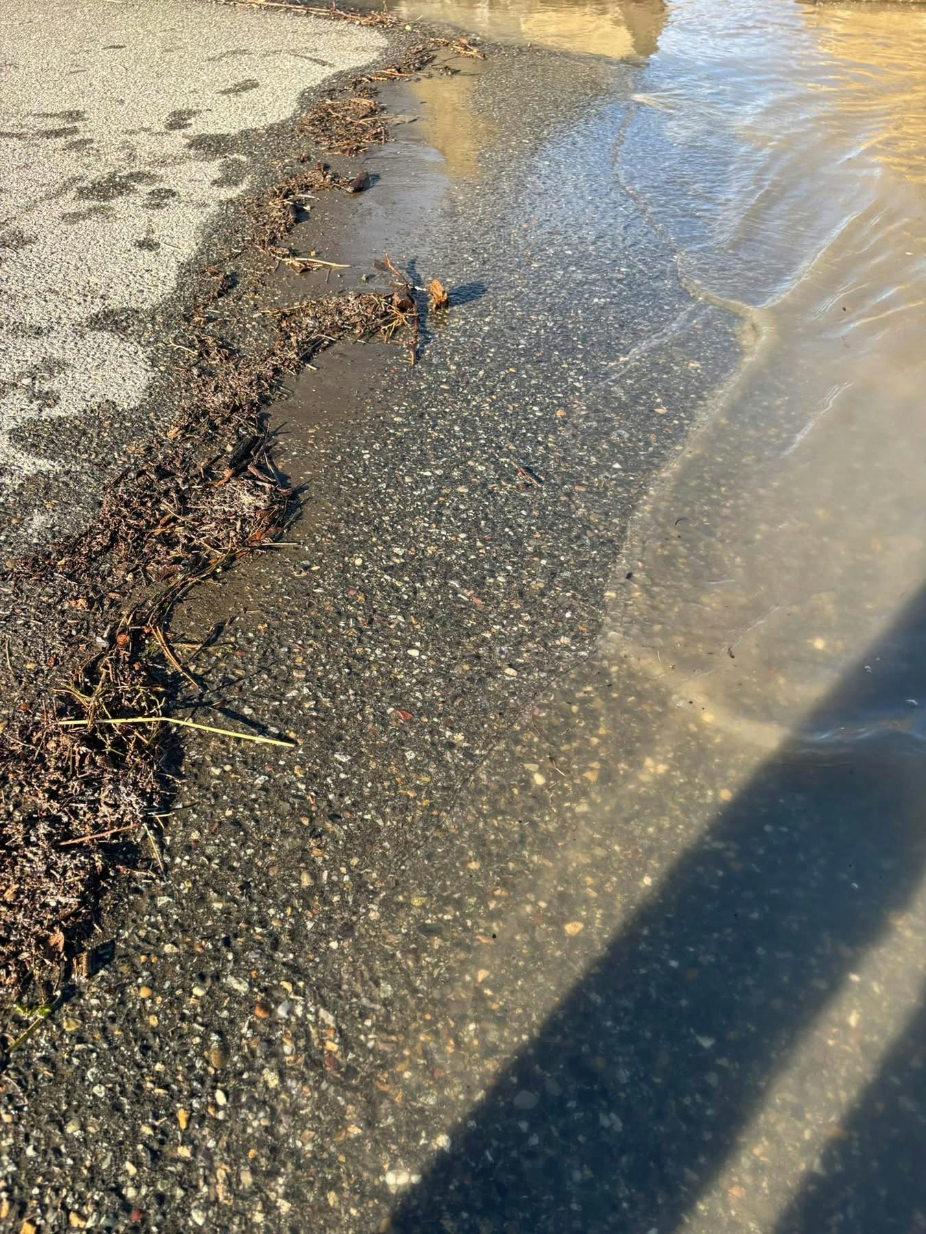
Please avoid Demoss Rd and do not drive through the water. Any disturbance to this specifc water on Demoss has an instant cause and reaction, onto the residential building near by. Please do not cause further issues for such residence.
We should start to see the water begins to recede here in the next hour or so.
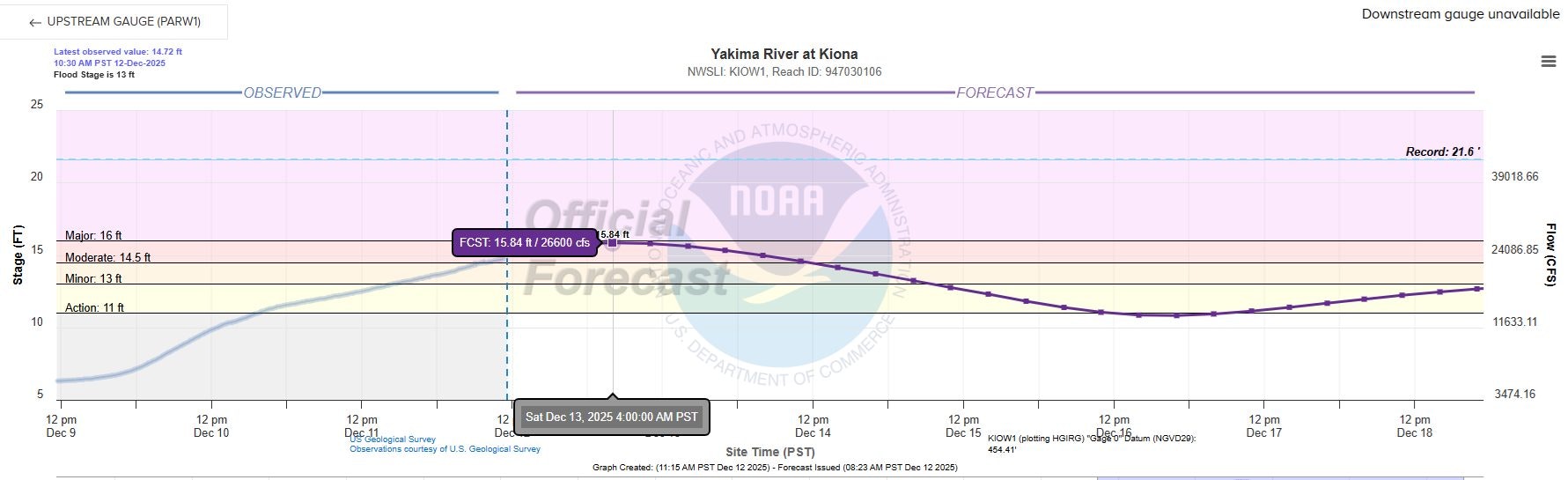
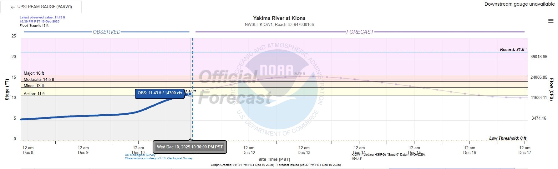
10/12/25. 2232hrs (10:32pm) - The new predicted Yakima River depth has been updated to 16.09’. This is a new depth number and highest we’ve seen predicted throughout this entire ordeal. The time of such depth has continued to trend and is still predicted for 0400hrs (4am) 12-13-25 **
Quick update and Shelter information:
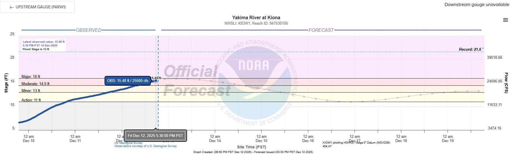
Yakima River levels have continued on their latest predicted trends. Currently at an approximated 15.48' as of 1730hrs (5:30pm) today and predicted to crest at 0400hrs (4am) 12/13/25 at 15.88'.
A Red Cross shelter has been opened at the Central Church in Richland, located at 1124 Stevens Dr. Richland, Wa.
As of right now, unless something catastrophic happens upriver, we do not anticipate 1st St. nor the Yakima River bridge to be closed. We are also seeing a trend of upriver depth indicators cresting and receding, so we are hoping that trend continues and soon our river marker will crest and recede as well.
We encourage everyone to continue to be cautious and alert. If you do not need to be in the area, please stay out. Again, if you have no immediate reason to be in the affected area, please do not visit the area.
Yakima River at Kiona live tracking https://water.noaa.gov/gauges/kiow1

12/12/25 12:00 (12PM)
As we inch towards the predicted peak level of the Yakima River, here are some things to keep in mind:
We still have sand and bags, supplied by Benton County Emergency Services and hauled by Benton County, WA Government, here at Station 210, 1304 Dale Ave. Benton City, Wa. 99320.
The crest is now again predicted to hit at 0400hrs (4am) December 13th. This is a concern for us, as most will be in bed and asleep. Please use day light hours to prep your property and to manage any preparations you deem necessary.
As the water levels rise, it would be good practice of those who will be affected, to use bottled water vs using any well water as well casings may become submerged and/or well water may have back flow from the river waters.
Don't drive through any flooded roadways. Just 6 - 12 inches of moving water can sweep a car off the roadway.
Conditions can change fast, and while we are comfortable with the forecasted river level, that does not mean something up stream can fail or break loose, producing a surge, resulting in a higher river level.
Be prepared for potential power issues and do your best to keep electronics at a minimum of 75% or greater, charge.
Prep and have ready, a "go bag" so that in the event something drastically changes, you are ready to leave at a moment's notice.
If you aren't from the area, and/or don't have a reason to be in the area, please stay clear of the affected areas as people are tirelessly working and making attempts to get their property moved. The last thing they need to deal with, are delays due to "lookie-loo" congestion.
Last and most importantly, if you feel you are in need of emergency services, please dial 911 immediately. We cannot stress enough that time is of essence, especially when dealing with water rescue related incidents.
For any other public safety needs that are not deemed an emergency, please make use of SECOMM's non-emergency line, 509-628-0333
(River photos credit of Benton County, WA Sheriff's Office)
12/11/2025 00:00 (12AM)
While your crews are out on their 12th call, we also went down and took a look at the current Yakima River level, and to monitor the current flow is currently doing.
As of right now, the water has a very fast pace, with quite a bit of an increase to go. The latest prediction of the river depth level is now showing depths higher than originally predicted and the time of which the river will crest, is now being forecasted to surge nearly 12-hours sooner.
As of this posting, the surge is expected to crest on Friday, December 12th at 2200hrs (10pm), at an approximate river level of 15.69'
SAND STATUS: As of right now, we still have some sand left, with an additional approximately (20) sandbags, that are pre-filled and ready to go. We have let BCES know of such, and are hoping to have it restocked for any citizens who are in need.
As the water starts to crest the riverbank walls, PLEASE stay away from the water's edge and do not attempt to go near it, nor retrieve anything from the water.
Yakima River at Kiona live tracking https://water.noaa.gov/gauges/kiow1

12/10/25 10:30 (10:30 AM)
Sand and bags have arrived at Station 210, located at 1304 Dale Ave. Benton City, Wa. 99320. The supplies are specifically located West of the main station, near the Maintenance Building. Please see photos for reference of the location of such, to include the preferred route of travel. Dale Ave is heavily used at certain times of the day, so please be cautious of other commercial traffic.
The sand and bags have been provided by Benton County Emergency Services, delivered by Benton County, WA Government, and the facility location provided by us, your local Fire Department.
This is a self-serve sandbagging station however, if you are in need of assistance, please call Station 210 and request such, the crew would be happy to assist you, if they are not out on an incident. Station 210 (non-emergency) - 509-588-3212.


12/10/25 10:00 (10AM)
We are continuing to monitor the river levels and as of this morning the forecasted river level depth has decreased by an approximate 0.7'. A new crest timeframe has been forecasted to be on 12-12-25 at approximate 1000hrs (10am). Which is great news, as the height of the surge will hit during daylight hours and not while everyone is asleep.
What does this mean?
- We will still more than likely hit a "moderate" flood stage
- The Yakima River will continue to increase its' depth and flow (CFS)
- The Yakima River will continue to purge hazards downstream, creating floating and sunken hazards, with the riverbanks edge, hidden in numerous areas
- We will very closely monitor it until we see the river level start to recede
- We are continuing to work with Benton County Emergency Services and other Fire Districts to keep well ahead of this evolving situation and to keep you, our citizens, well informed
- Regionally, we have all met to ensure Public Safety and Outreach regarding this situation
Yakima River at Kiona live tracking https://water.noaa.gov/gauges/kiow1


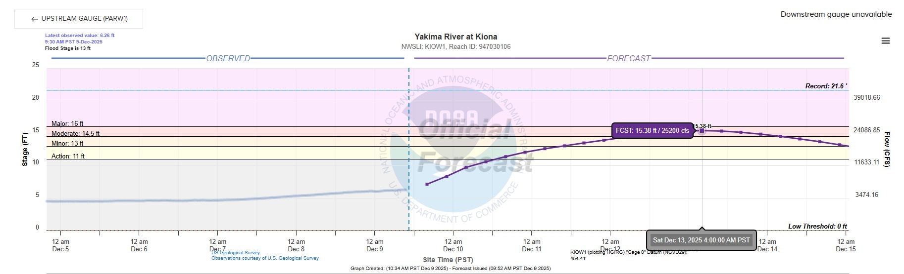
12/09/25 14:30 (2:30 PM)
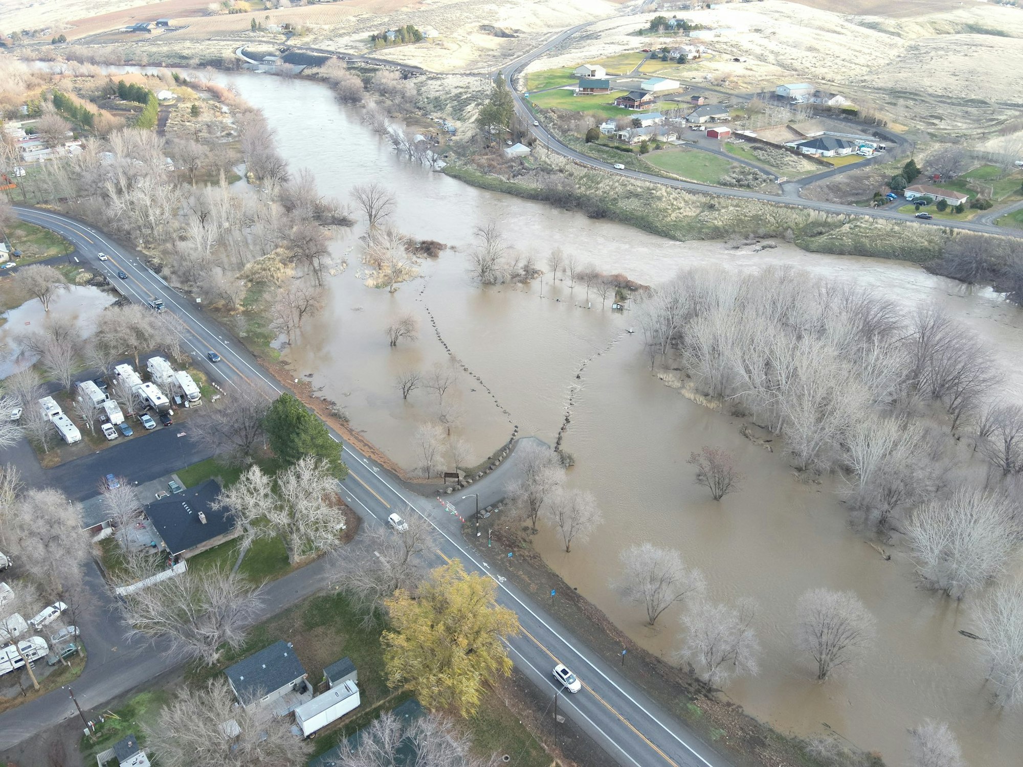
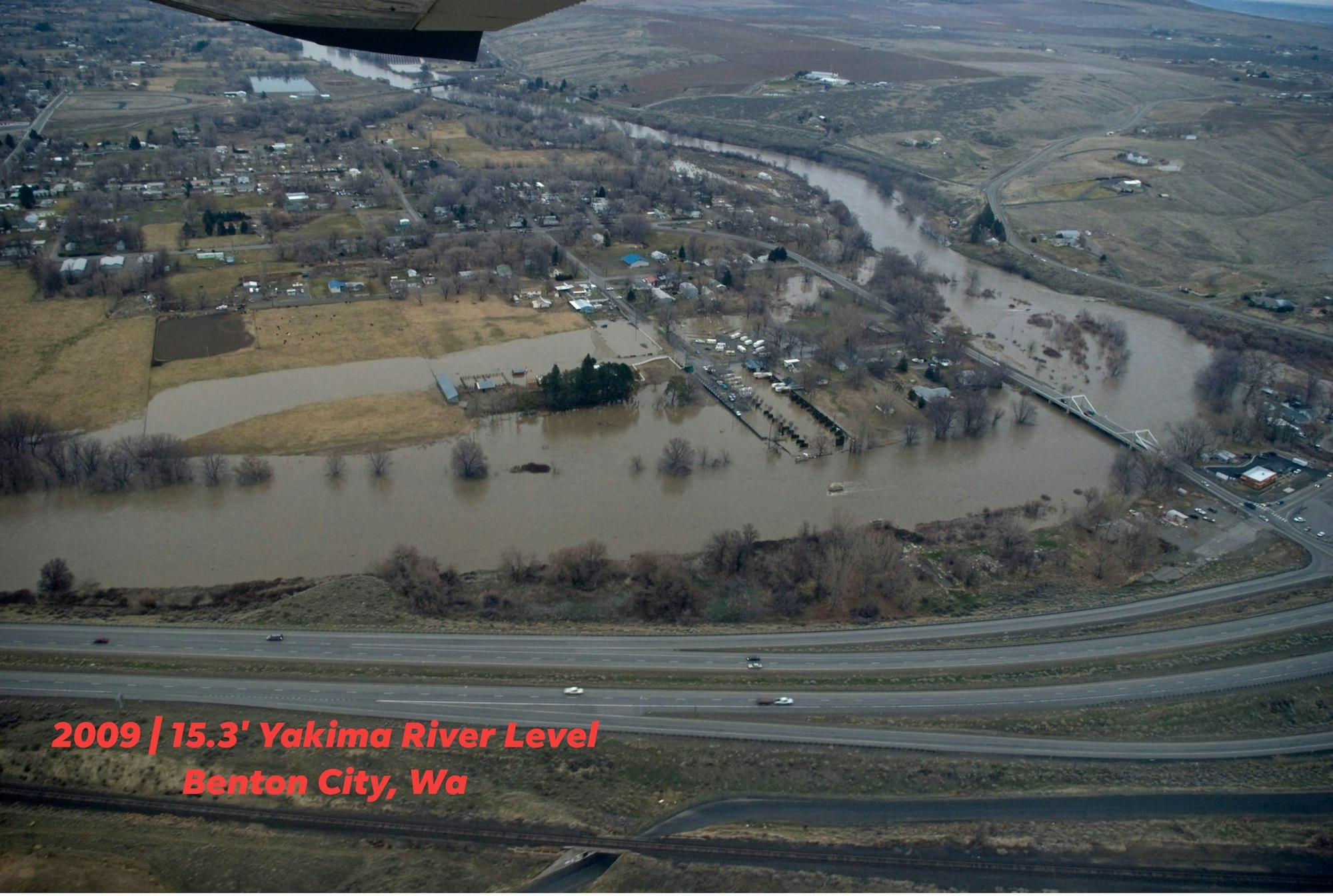
Big thanks to Benton County Emergency Services, as we have been provided a photo of what could be expected in the Benton City area, for leading into and on Saturday the 13th.
The photo attached is from 2009 when the Yakima River reached 15.3'. The Yakima River is expected to crest at nearly the exact same river depth of what is being predicted; 15.38' for 0400hrs (4am) Saturday the 13th.
Also thanks to BCES, we will have sand and bags, located here at Station 210 for our citizens. We will make a post once that is here and setup, and any other details pertaining to the sand/bags.
(Again, this photo is from 2009 with a 15.3' River level and is being shared as something to reference. This is NOT a current photo)
12/09/25 12:00 (12PM)
Now that the wind has calmed, we are as always, closely monitoring the Yakima River. At the time of this posting, it is forecasted to rise to a moderate flood stage, peaking at 15.38' on Saturday December 13th @0400hrs (4am) (these numbers are provided by NOAA & NWPS). While the predictions are not 100% precise, they are usually relatively accurate and used frequently by our water experts.
We are already seeing the "wave", hit the Upper Yakima, in areas such as Nile and Naches, and so we are monitoring those river levels in comparison to their predicted levels as well. As of right now the river has taken out the lower Nile bridge and is threatening the Wonderland Campground bridge as well.
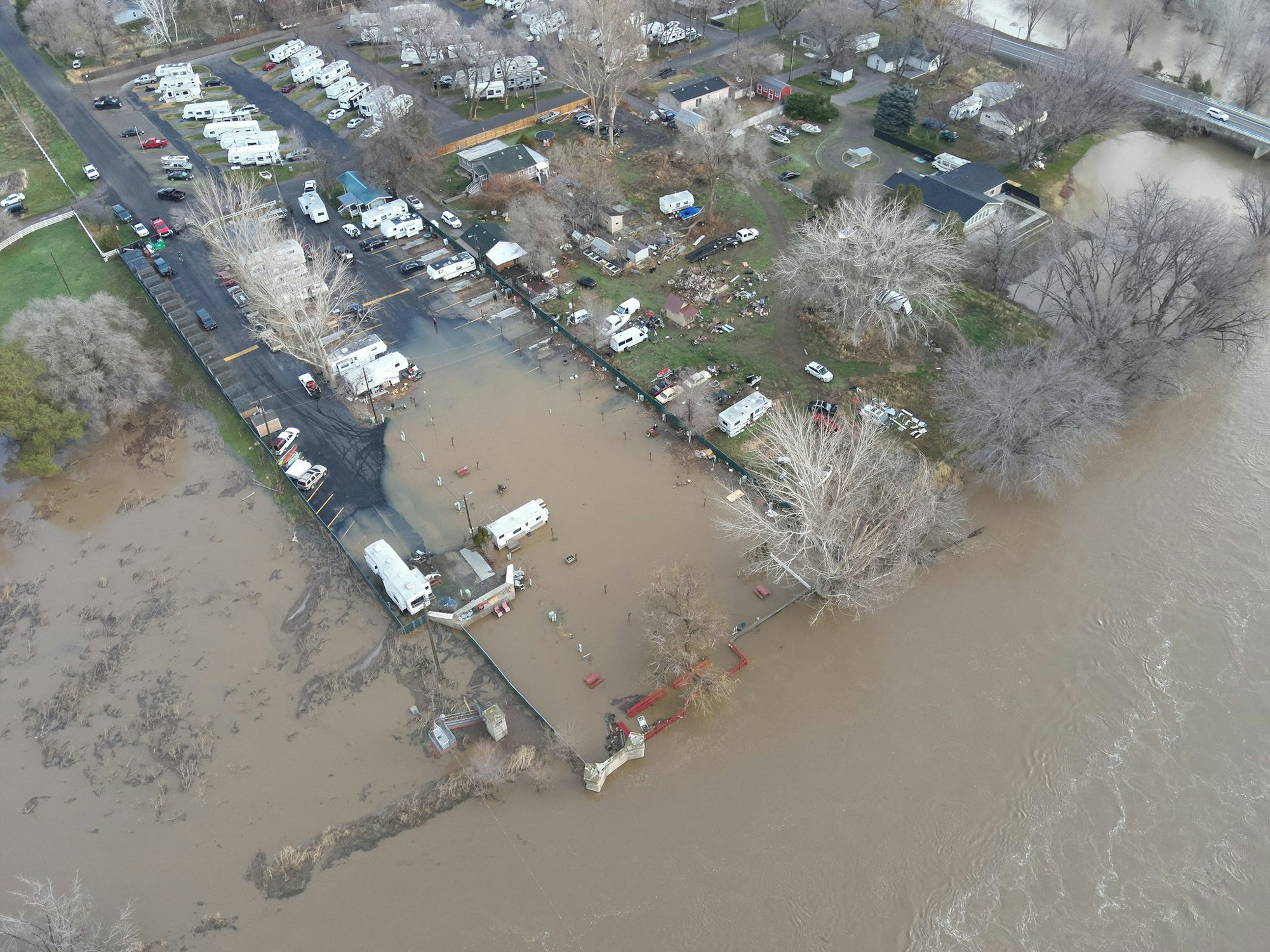
At the anticipated and predicted 15.38' Yakima river level, we except to see water in low lying areas, but not limited to, the following locations:
- Beach RV
- East end of Carol Ave
- Hope Lane
- Alma & Babs
- E. Pendleton Rd
- E. Massingale
- Demoss Rd
We do not anticipate any massive widespread flooding, but mother nature can change course quickly, so please be cautious and mindful. There will be numerous hazards, both in the water unseen, and floating downstream. Please avoid recreating on the Yakima River for the week or so.
If your property has flooded in previous years, please take precautions now. Keep in mind that even if your property didn't flood in previous years, flood patterns change from year to year and dependent on storm size and surge, can vary from "flood" to "flood" as well.
For reference, the flood of '96 produced approx. 20.98' river levels and in the most recent years, the highest river level we had was in 2016 of which was an approx. 13.53'.
SUGGESTIONS:
- Remove any valuable items from low lying locations, ie fields, basements, cellars, etc.
- Keep away from riverbanks and any bodies of water, as you will not be able to tell the depth of such. DO NOT attempt to cross any moving water with vehicles.
- To report any emergencies, and/or any situations what required emergency assistance, please call 911 immediately. Time is of essence in any emergency but especially water emergencies.
Yakima River at Kiona live tracking https://water.noaa.gov/gauges/kiow1